Geotechnical Vulnerability
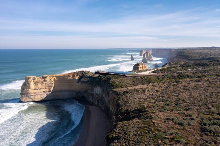
Coastal cliff retreat across the Australian continent has transitioned from a gradual geomorphological process to an acute infrastructure crisis. With over 80% of the national population residing within 50 kilometers of the sea, unstable escarpments directly threaten billions of dollars in public assets, residential real estate, and iconic transport corridors like Victoria’s Great Ocean Road.
Unlike sandy beach erosion, which often exhibits cyclical patterns of erosion and seasonal recovery, cliff failures are permanent, episodic, and highly catastrophic. A single failure event can displace thousands of tonnes of lithified material within seconds, leaving no opportunity for structural remediation or localized intervention.
In 2026, the intersection of rising sea levels, increased wave energy fluxes, and altered groundwater tables has accelerated destabilization rates across vulnerable lithologies. Predictive modeling is no longer an academic exercise; it is the primary mechanism for establishing structural setback zones and designing regional adaptation pathways.
Predictive Limitations
The primary point of failure in historical coastal planning was relying on linear retreat rates. Engineering firms frequently used simple historical averages, such as assuming a cliff retreats at a uniform 0.1 meters per year, to calculate safe infrastructure setbacks for a fifty-year asset lifespan.
This deterministic approach completely misjudges the mechanics of soft-rock escarpments. Cliff collapse is a threshold-driven phenomenon governed by complex feedback loops between marine forcing at the cliff toe and subaerial weathering at the cliff face. A cliff may appear perfectly stable for two decades before suddenly retreating twenty meters during a single East Coast Low storm event.
Ignoring these non-linear triggers results in severe real-world consequences. Coastal assets are frequently placed well within active hazard zones, forcing local councils into reactive, capital-intensive engineering interventions like rock armor revetments or permanent road realignments that degrade local beach ecosystems.
Advanced Modeling Frameworks
The ASCCIE Methodology
The Areas Susceptible to Coastal Cliff Instability and/or Erosion (ASCCIE) framework represents the current gold standard for regional-scale hazard mapping in Australia. This model separates cliff retreat into two distinct analytical components: localized cliff-toe regression and deterministic slope stability profiling.
In practice, the model determines a geotechnically stable angle for specific geological formations based on their shear strength and internal friction angles. When sea-level rise triggers accelerated toe erosion, the model calculates how far landward the upper cliff crest must recede to re-establish that stable slope profile over a targeted planning horizon.
Bayesian Network Systems
To capture the episodic nature of escarpment failures, engineers deploy multi-parameter Bayesian probabilistic networks. Rather than predicting an exact date of collapse, these networks calculate the joint probability density function of a failure occurring based on independent environmental inputs.
The system ingests real-time variables, including deep-water wave heights, storm-surge duration, antecedent rainfall metrics, and structural joint density data. This approach allows coastal managers to run localized simulations, determining that a specific soft calcarenite cliff has an 85% probability of major failure if subjected to a forty-hour wave impact event.
Digital Earth Integration
Modern modeling relies heavily on Digital Earth Australia (DEA) Coastlines data, which integrates over three decades of Landsat and Sentinel satellite imagery. By combining this archive with localized tidal models, scientists extract highly accurate historical baselines at thirty-meter intervals along the entire continent.
This data corpus allows models to isolate long-term regional trends from short-term seasonal anomalies. Consultants use these calibrated satellite baselines to validate process-based numerical models, ensuring that forward-looking simulations accurately reflect historical morphological responses to past climate anomalies like multi-year La Niña cycles.
Hydrodynamic Wave Forcing
Process-based numerical models simulate the precise mechanical work performed by waves breaking at the cliff base. By coupling nearshore wave transformation models with geomechanical models, engineers can quantify the hydraulic plucking and abrasion forces exerted on the rock face.
These models map wave energy concentrations along irregular coastlines, identifying localized wave-focusing zones caused by offshore bathymetry or sub-aquatic reefs. This level of resolution explains why two adjacent sections of the same sandstone cliff line experience vastly different rates of localized undercutting.
Subaerial Weathering Modules
Escarpment failure is not driven solely by marine action from the ocean; subaerial processes occurring from above are equally critical. Modern predictive suites incorporate dedicated groundwater and rainfall infiltration modules to track pore-water pressure variations within the cliff matrix.
During prolonged rainfall events, water fills vertical tension cracks behind the cliff face, generating high hydrostatic pressures that push the rock mass outward. Advanced simulations couple this internal hydrologic stress with mechanical wave undercutting, providing a holistic view of structural stability during compounding storm events.
Regional Strategic Outcomes
The Mornington Peninsula Shire deployed a multi-stage coastal hazard adaptation strategy utilizing advanced erosion modeling to evaluate localized long-term risks. The technical assessments revealed that without proactive structural adaptation, the projected average annual cost of hazard impacts would escalate rapidly.
Short-term costs through 2040 were modeled at $8.6 million annually, but medium-term projections through 2070 escalated to $22.0 million. By the year 2100, the modeled financial exposure reached a staggering $67.3 million per year, driven by compounding infrastructure damage and asset loss across eleven priority townships.
Faced with these figures, the council avoided short-sighted, reactive spending. Instead, they utilized the localized hazard maps to develop distinct adaptation pathways for specific subareas, implementing a combination of updated land-use planning controls and offshore wave-attenuation structures to defend key public spaces.
Analytical Tool Comparison
| Model Class | Primary Input | Output Type | Scale Focus |
|---|---|---|---|
| Empirical | Satellite trends | Retreat rate | Regional |
| Probabilistic | Bayesian data | Failure chance | Segmented |
| Numerical | Wave mechanics | Stress maps | Site specific |
| Geomechanical | Borehole core | Factor of safety | Asset level |
Mitigating Assessment Errors
A frequent error in engineering assessments is utilizing low-resolution bathymetric data for nearshore wave propagation models. If the sub-aquatic topography fronting a cliff line is poorly resolved, the model cannot accurately compute wave shoaling, breaking positions, or localized energy concentrations.
To avoid this, engineers must collect high-resolution airborne LiDAR or multibeam sonar data in areas identified as high-risk during first-pass assessments. Accurate shallow-water bathymetry ensures that the hydrodynamic forces applied to the cliff toe in numerical simulations match real-world conditions.
Furthermore, failing to account for talus accumulation at the cliff base can skew long-term retreat forecasts. When a cliff collapses, the resulting debris pile temporarily protects the toe from wave action until marine processes clear the material. Models must simulate this clearing time to avoid overestimating immediate subsequent retreat.
FAQ
What is a second-pass assessment?
A second-pass assessment is a regional or state-wide study that uses simplified geological and topographical rules to identify broad areas susceptible to instability. It filters out low-risk zones so councils can focus detailed, site-specific engineering resources on verified high-risk hotspots.
How does climate change alter models?
Climate change alters the baseline forcing variables. Models integrate varying sea-level rise scenarios, ranging from 0.2 meters by 2040 up to 1.4 meters by 2100, alongside projected increases in storm-surge frequencies, to evaluate how risk profiles accelerate over time.
Can vegetation prevent cliff collapse?
Vegetation is highly effective at stabilizing shallow, unconsolidated soil slopes and sand dunes by reducing rain infiltration and binding upper soil layers. However, deep-seated structural failures in lithified rock cliffs are governed by geology and marine forcing, which root systems cannot mitigate.
What is talus runout distance?
Talus runout distance refers to the horizontal area at the base of a cliff that collapsed debris will cover after a failure event. Modeling this zone is critical for protecting beach users, coastal walking tracks, and lower-level marine infrastructure from falling rock impacts.
Are bathtub models useful for cliffs?
Simple bathtub models, which map static sea-level rise over topography, are useful for low-lying inundation screenings but are wholly inadequate for cliffs. Cliff erosion requires dynamic models that evaluate mechanical wave action, slope angles, and structural rock strength.
Author's Insight
Throughout my years conducting geotechnical field assessments along the southern coastline of Australia, I have seen numerous multi-million-dollar infrastructure assets placed dangerously close to active active failure scarps based on flawed linear calculations. The shift toward probabilistic Bayesian networks has completely changed our approach to risk communication. It is far more impactful to present a local council with a concrete probability of collapse under specific storm parameters than a vague, long-term average rate of retreat. Planners must realize that when dealing with indurated rock escarpments, preparing for the episodic worst-case scenario is the only responsible pathway forward.
Summary
Managing the accelerating threat of coastal cliff erosion across Australia requires a major shift toward non-linear, process-based predictive modeling. By integrating advanced frameworks like the ASCCIE model, utilizing multi-temporal satellite data, and conducting detailed geotechnical investigations, planners can accurately map out future vulnerability zones. The key to successful coastal management lies in translating these complex spatial models into actionable, long-term adaptation pathways that protect public safety and minimize infrastructure expenditures before catastrophic failure occurs.